A Huge proposal with Huge Implications
This is the 2nd in a series of posts on these properties.
- San Group’s Pacific Mayfair Estates takes over Beaver Ponds – Maybe They Should Donate The Land.
- This Post
- Beaver Pond Development – Good City Building?
Things are moving very very quickly in Port Alberni when it comes to development. That makes it very difficult for concerned citizens to keep up and potentially apply some pressure on the brakes.
On Friday, San Group/Pacific Mayfair Estates likely made what amounts to the largest announced residential plan in the history of Port Alberni. But let us not be dazzled by the big numbers and look at what this will actually mean for the area.
Updated – AVNews Article – Red Listed Species at Risk
A Monday August 30 news article quotes local naturalist and retired forester Sandy McRuer:
“I’d like to see the entire property saved,†says Sandy McRuer, a retired professional forester and former outdoor tour guide. McRuer is one of several people advocating for protection of the beaver ponds.
McRuer said the ponds are not only home to a pair of beaver dams and a number of beavers, “it’s habitat for the painted turtle and that is a red-listed creature. They will have to find where these creatures nest and make sure they are not disturbed.â€
Sandy has an excellent blog here.
San Group now owns all three Burde properties.
As an indication of just how fast this has been happening, in my last post earlier this month about San Group’s new “Pacific Mayfair” company I had found that San Group only owned two of the three properties around the south side of the Beaver Ponds, not the “Harris Property”. That is no longer the case according to the Land Owner Title Registry today.
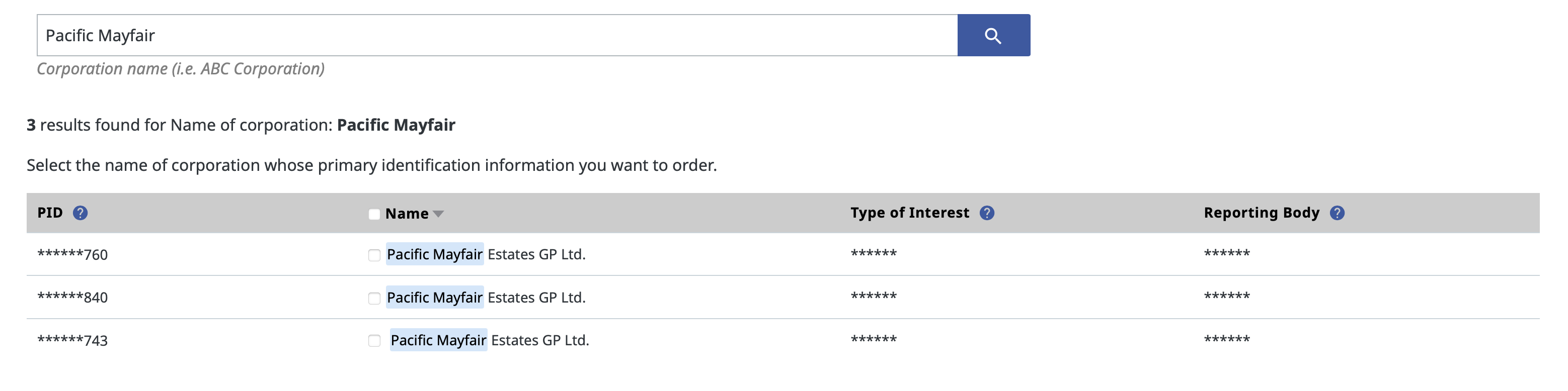
No need to pay to reveal the details of each property as the final three numbers match the three properties on the east, west, and south side of the Beaver Ponds.
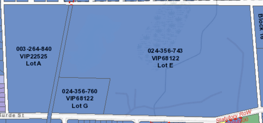
Here are the properties right now on Google Earth:

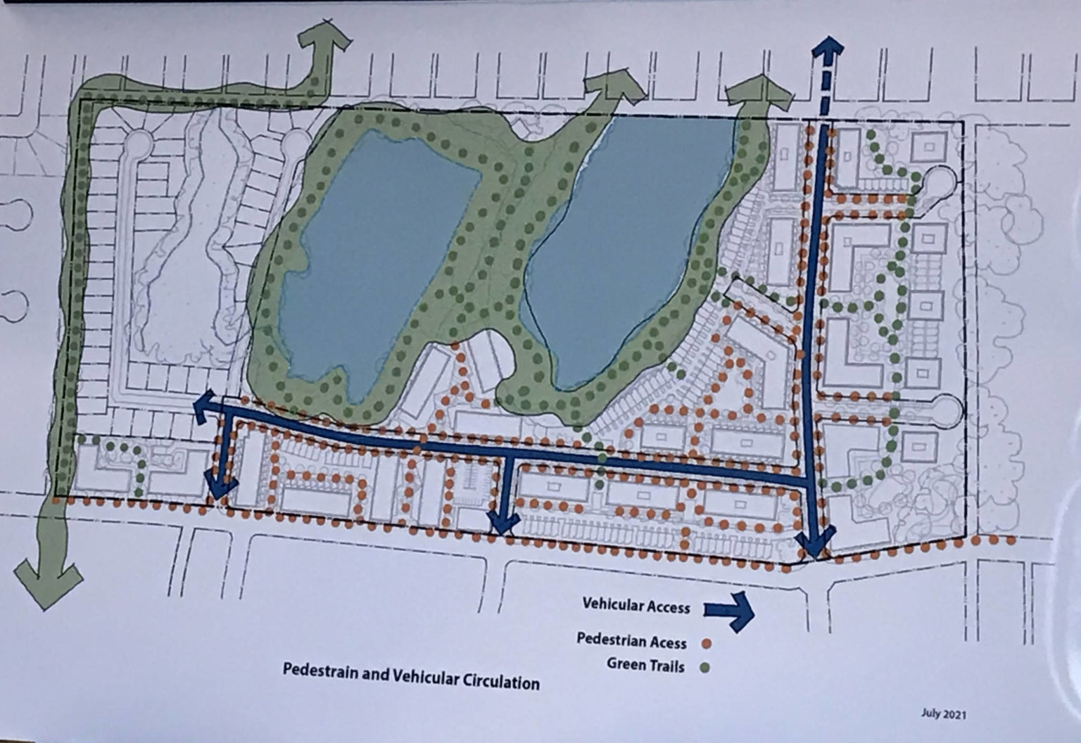
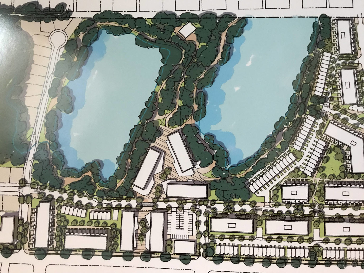
Here is the San Group’s concept drawings of their development for the same area (courtesy AVNews)
This one appears to be a close up of the ponds themselves.
I immediately see some major changes and potential issues.
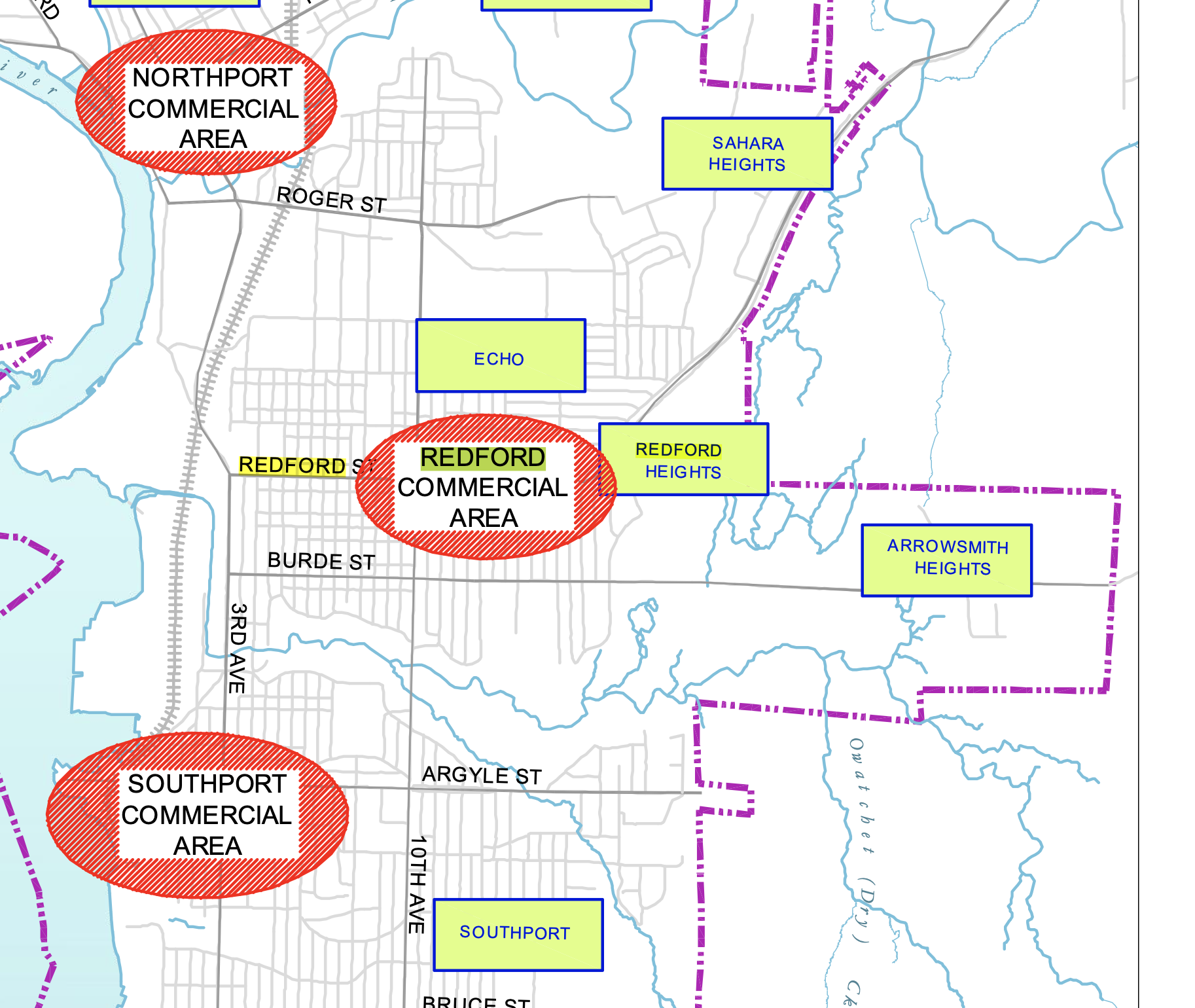
Issue #0 – Words from the Official Community Plan
We have to start at zero, and in City planning, that’s the Official Community Plan. The ponds have many names, Beaver Ponds, Burde Street Ponds, and even Redford Ponds.
Here is a map from the OCP that explains the last name. In that official Port Alberni document, the area is kind of sandwiched between the neighbourhoods of “Redford Heights” and “Arrowsmith Heights”.

The ponds are the only bodies of water specifically mentioned in the OCP.
Redford Ponds and tributaries and similar environmentally sensitive areas comprise significant wildlife habitat and shall be subject to habitat protection policies as determined through detailed environmental analysis.
Page 24 – OCP 2007 Port Alberni
As the guiding document for all development in the City, this is a critical piece of information for citizens, the Advisory Planning Commission, the City Staff, and the City Council alike.
Issue #1 – Log Train Trail right of way levelled, paved, re-routed.
Here is the LTT now:
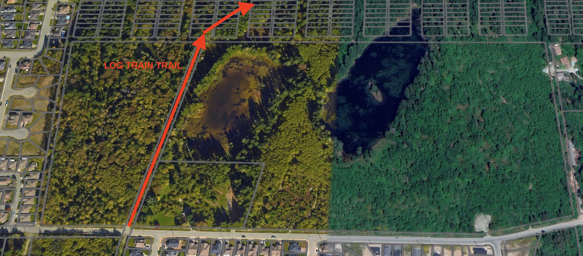
Notice the trail goes up through the forest on a designated right of way before curving away as it crosses the City boundary into the Crown land/Hupacasath wood lot.
Now look at the San Group plan again. Notice the trail becomes road along the same path beside the lower pond. There are many other roads as well (I’ll come back to that). The vast majority, if not all, of the forested area is removed.

The Log Train Trail is re-routed around the East (left) side of the new neighbourhood of homes sandwiched between the existing gated neighbourhood and the new one right beside this City utility shack.

QUESTIONS:
- Will this be a gated community?
- Will the Beaver Ponds even be accesible from the Log Train Trail?
- Will the public be able to enter this area anymore? The drawings have a certain “country club”, or at least “gated community” kind of feel to them. Developers are free to make neighbourhoods as they wish, however, the Beaver Ponds are historically a treasured area of public access to nature in Port Alberni. Will this expectation of access change?
Issue #2: Seven New Roads
The two Beaver Ponds comprise about 92,000 square meters (22 acres) of the 292, 469 m2 (72 acres) of area.
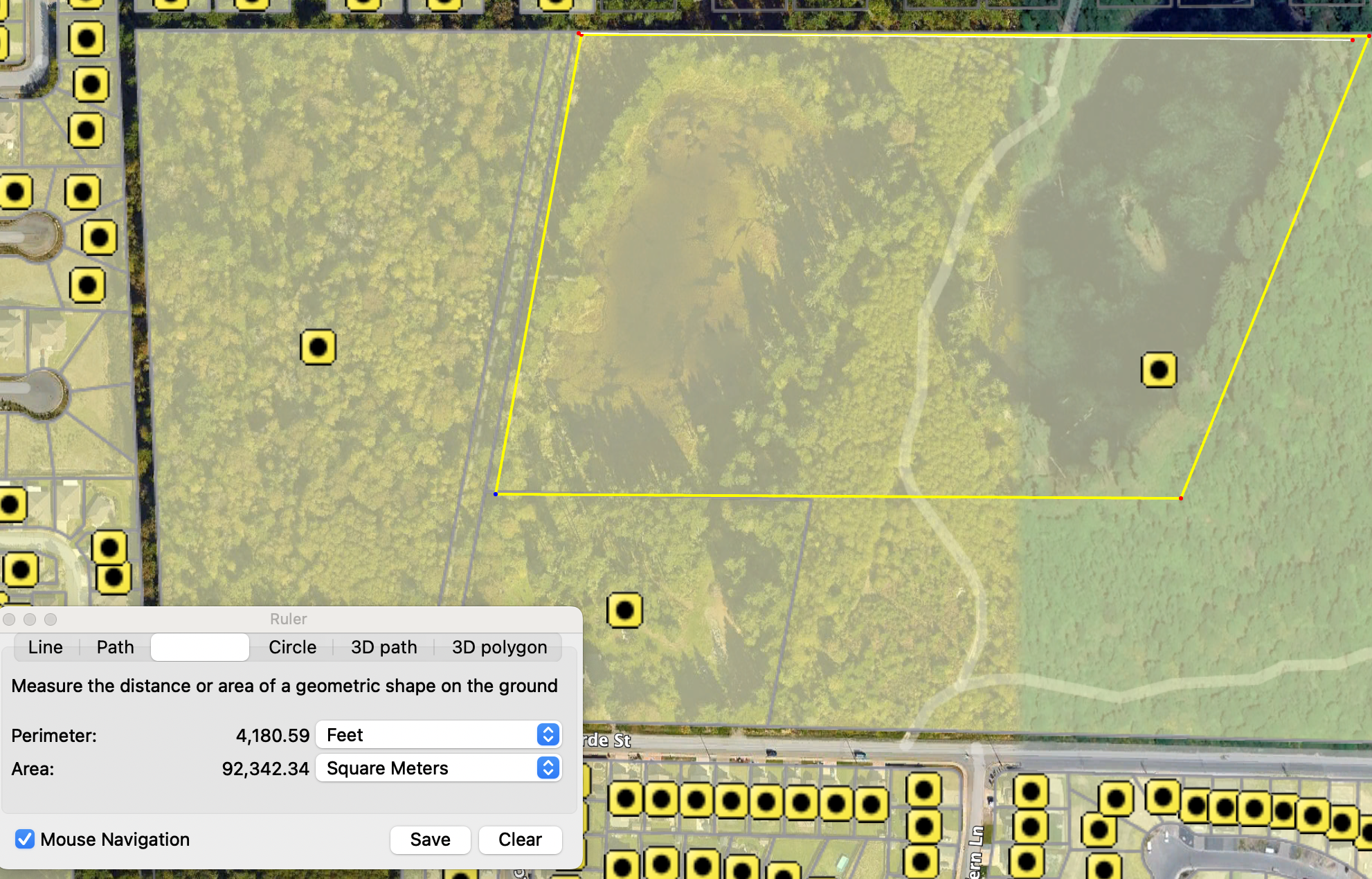
That leaves about 200,000 m2 (49 acres) of non-wetland/pond (ignoring Wolf Creek for a second) for them to develop. On that they intend to create 7 new roads including:
- 3 accesses to Burde Street
- 1 main East/West connector between Burde and the ponds
- 4 cul-de-sacs to new neighbourhoods or apartment blocks
- 1 main road that exits the development to the northeast. (more on that later)
These roads, the pictured buildings and new residential lots imply large amounts of new car traffic, a complete change in the landscape, and obvious displacement of nearly all existing wildlife and ecosystems in the area.
Issue #3: Will this connect to Highway 4 through the Rogers Creek Watershed?
That arrow to the northeast raises huge questions for me.

Below is a wider view of the whole area, the blue arrow is a continuation of the arrow in San Group’s plan which appears to follow the original street layouts for the City. The red line is the current Log Train Trail. The green line is an existing logging road in the woodlot.
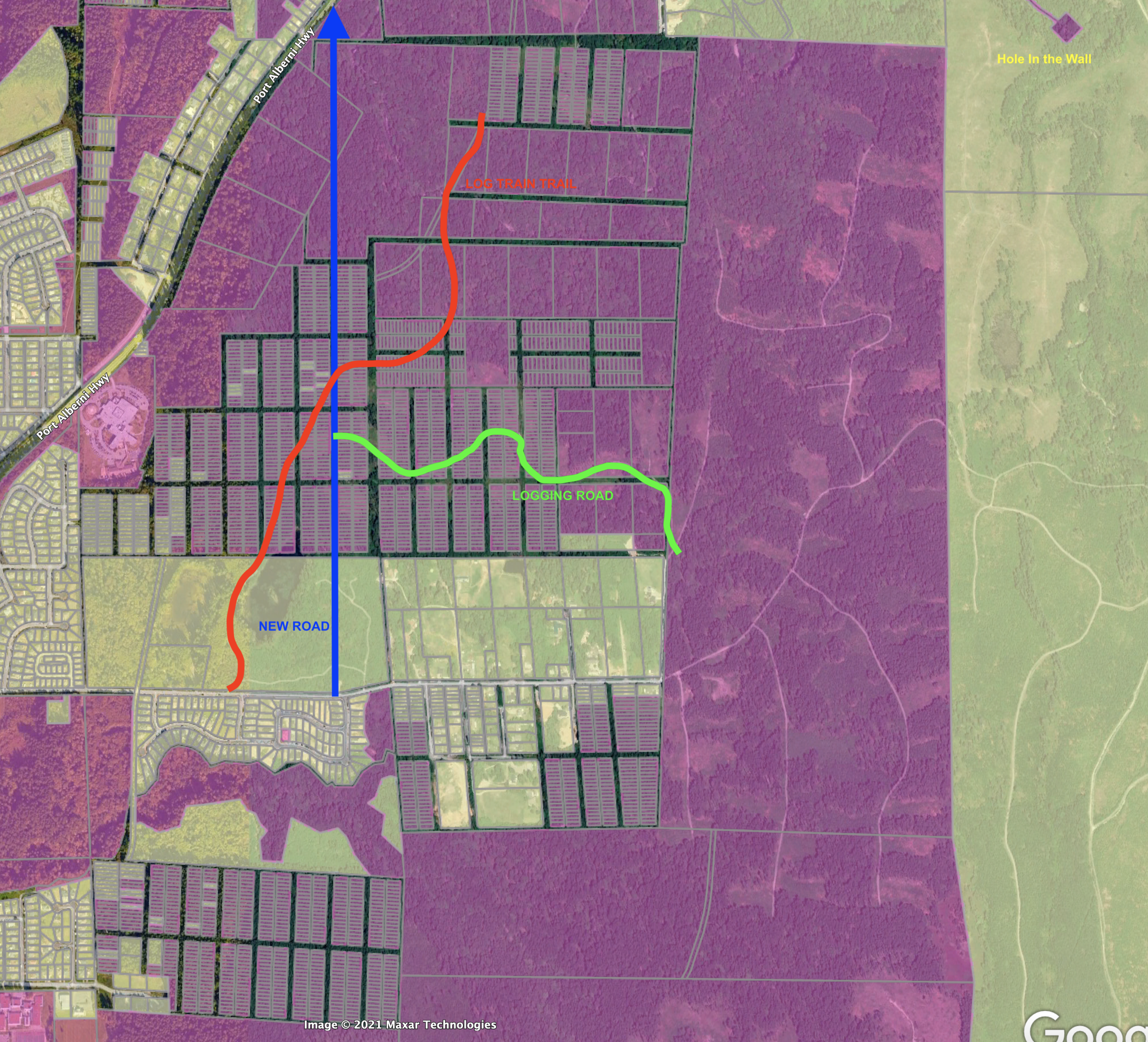
So is there a future plan for that blue line to go through somewhere or was this just a random part of the drawing? Well it just so happens that there is a “proposed bypass” that has long been on the books, including in the OCP road network map (page 53). It’s the green dashed line below.
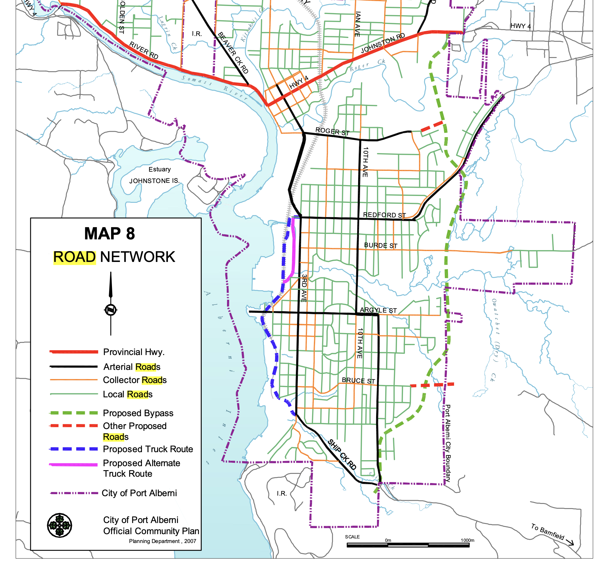
The road would go behind the hospital to connect to Redford and Highway 4 just beyond the Hospital and would connect to Ship Creek to the South.
As the land immediately to the north is a wood lot leased by Hupacasath, this would obviously be pertinent to their interests as well. (as would all of it to both Tseshaht and Hupacasath as part of their un-ceded territories).
The road network implications, and intent of both the City and SAN Group is very important in this question and shouldn’t be overlooked.
Issue #4: What to do with Wolf Creek?
Just to the west of the lower Beaver Pond is Wolf creek.
It is not on Google Maps for some reason, but I did find it on this trail map.
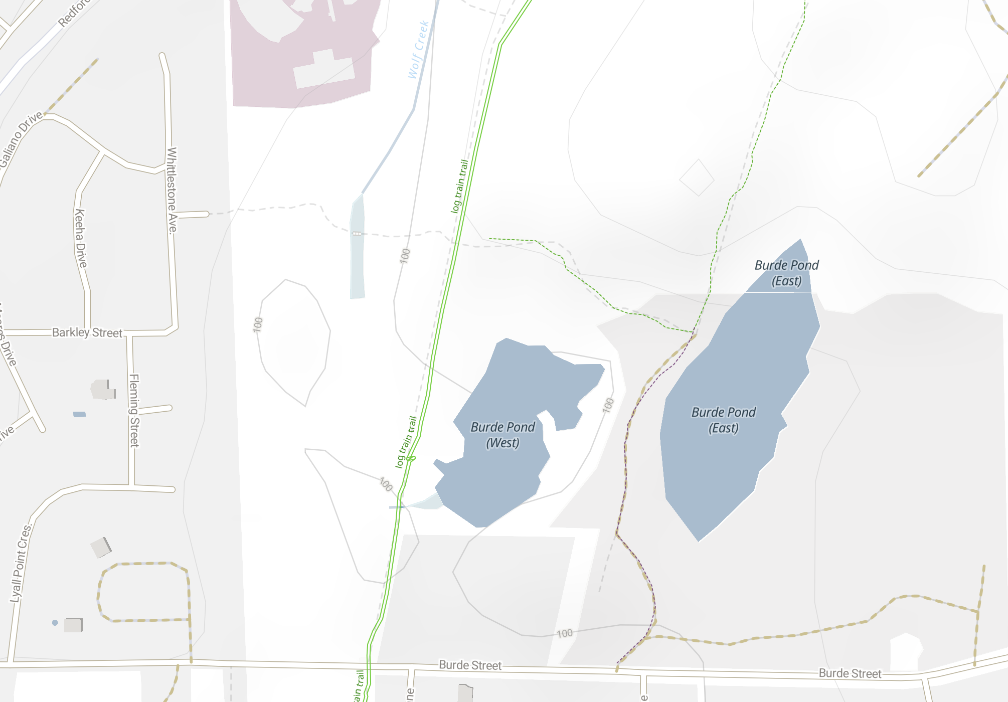
And it is also in the previous picture from the Official Community Plan.
You can see it running beside the hospital just north of the eastern property. There is quite a big boggy area closer to the western Beaver pond on the west side of the trail and the city map shows the creek connecting to the lower pond at the south end.
I have marked the boggy area at the head of Wolf Creek on the more familiar map below.
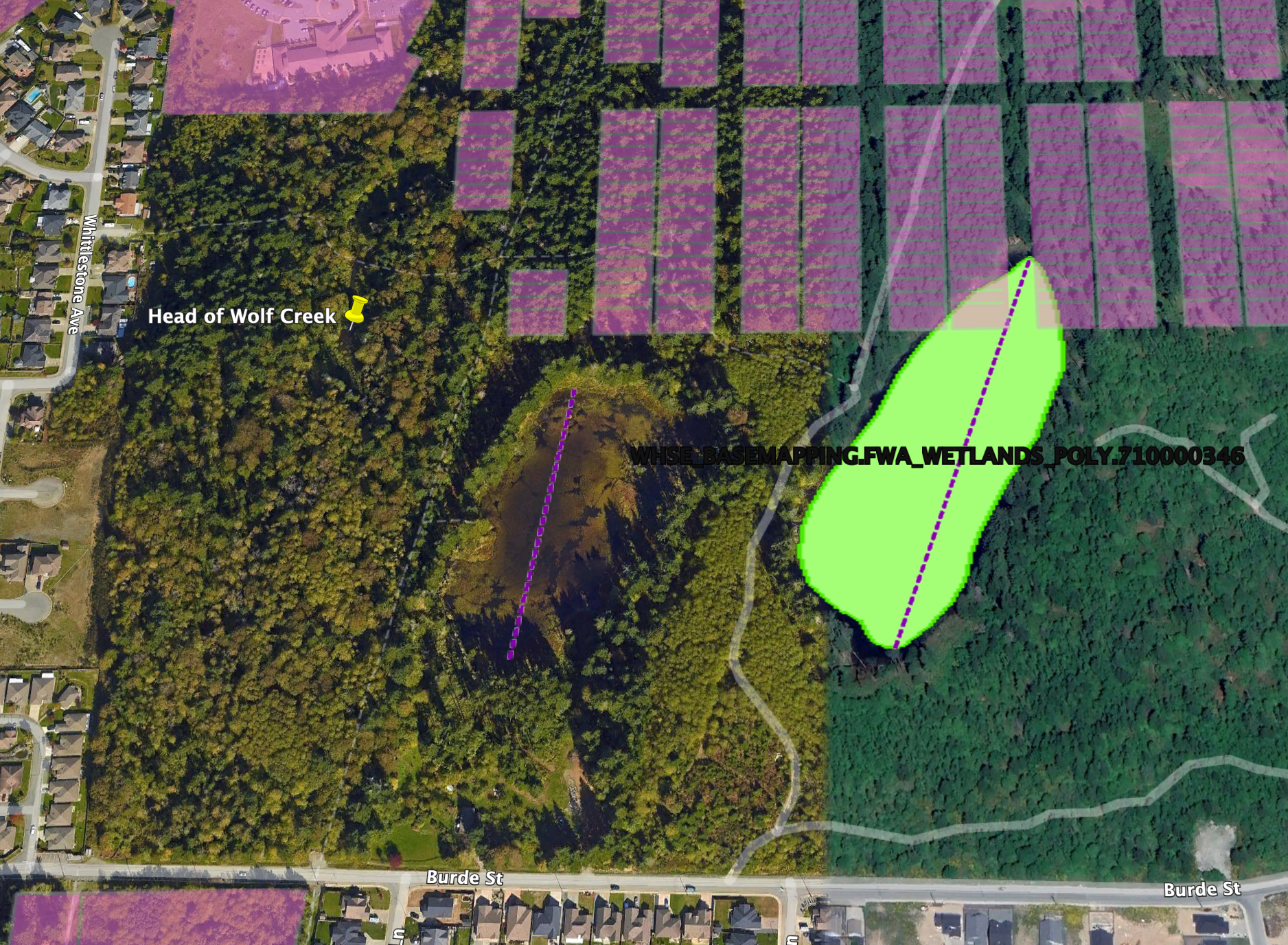
Obviously the proposed development, as pictured, would completely disconnect Wolf Creek from the lower pond.
I should also share this quote from former Port Alberni Mayor and now San Group spokesman Mike Ruttan published by The Peak:
“Ruttan said Wolf Creek was the most productive salmon tributary of Roger Creek before the beavers blocked the creek a decade ago.”
Removing the tree cover directly adjacent to both the ponds and the stream will make Wolf creek much more susceptible to drought. Which, as a former salmon bearing stream is a very important feature of the area and means the Ministry of Environment and Department of Fisheries and Oceans will need to be engaged to ensure everything is done to rehabilitate and protect the creek.
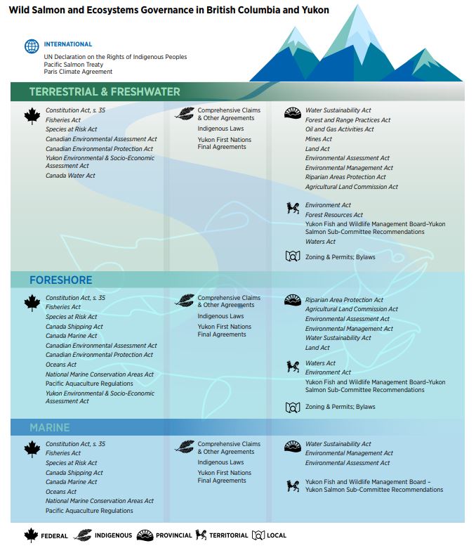
The handout below from DFO shows the web of regulations and acts that will be needed to be considered and followed when dealing with Wolf Creek under “Terrestrial & Freshwater”.
What will be done to protect this “most important tributary” to Rogers Creek?
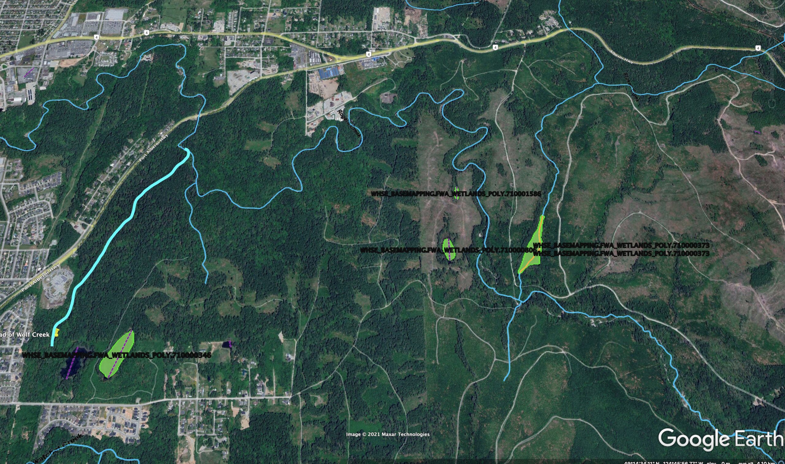
It is worth pointing out how impacted the Rogers Creek (light blue lines above) watershed already is by logging in the area particularly in the Mosaic controlled land outside the Hupacasath lease. I’ve drawn in Wolf Creek on the left. You can see pretty clearly the line down the middle of the image which is the boundary between the Hupacasath and Mosaic lands.
The green shaded areas are designated wetlands by the Province. Notice they are like watery islands in a clearcut desert. The Beaver Ponds, on the other hand, are quite uniquely surrounded by second growth forest and the logging is far less intensive.
(Bravo to Hupacasath First Nation for their forestry management)
Issue #5: The Beavers (and their ponds)
I would challenge the former Mayor’s characterization of the beavers:
“the beavers move away every year and then come back when the rains come, so we just need to work with that,†he said. “They can go into some other tributary of Roger Creek, or somewhere else in the system, just not there.—
It appears the former mayor has fallen into a common trap of assuming Beavers can either be removed or relocated and that their services are not beneficial.
Here is a good resource from The Fur Bearers:

Landowners and municipalities are justifiably concerned by the presence of beavers, as the dams and lodges they build can influence the flow or level of surface water and lead to infrastructure damage. As they build these dams and lodges, they take down some trees of specific species, which can frustrate property managers.
Often these issues result in municipalities or landowners hiring trappers to kill families of beavers. And while lethal trapping may seem effective, it is only a short-term solution. More beavers will soon return to the area to fill the open niche. This is an especially tragic decision because there are many cost-effective, non-lethal options to prevent flooding from beaver dams and to help control tree-chewing. These non-lethal approaches, in addition to respecting beavers, values the vital ecosystem services beavers provide for our environment.
By creating the beaver ponds, the beavers are retaining water which, as we know all too well this year, is a precious resource. This makes Wolf Creek and Rogers Creek more viable as salmon bearing streams. There are many ways to successfully protect beavers that allows for some development. But there is no doubt the scale of the development around the ponds would probably not be able to support the beavers.
Is that OK?
Issue #6: From natural ponds, to man made water feature.
It is pretty obvious from the drawings that the concept of the ponds is going to change dramatically.

They will no longer be two wetlands and ponds in a forest, but rather be transformed into two manicured water features at the centre of an exclusive development with landscaped trees, utility and entertainment buildings between the ponds and trails around them.
It may be a nice place to live, but it will certainly not be a natural place surrounded by forest with beavers, bears, cougars, deer, birds, and other important parts of the ecosystem in and around the ponds.
Issue #7 – The Big One – Climate Change
With our changing, and rapidly heating climate we should be very concerned about the potential impact of the loss of this wetland, forest, and salmon bearing stream. Climate change is already stressing many of the systems that this development will also stress. Any decisions in land development today must be taken with the view of how it will be impacted by climate change today and in the decades and centuries to come.
What to do?
There is plenty you can do!
- I would recommend looking at the Port Alberni Official Community Plan (pdf), which refers to the Beaver Ponds as the “Redford Ponds”.
- The San Group indicated it has already completed a lot of Environmental and other reports on the properties. Ask San Group to make all reports public.
- Keep an eye on upcoming meetings of the Advisory Planning Commission. (The next one is September 2nd but the agenda does NOT include this development, the following APC meeting is scheduled for September 16). This is where there will be initial discussion on the merits of having the lands rezoned and repurposed.
- San Group has stated that they will be conducting a Public Consultation process. Participate!
- Assuming the APC moves the issue forward, the lands will come to City Council through a Rezoning Hearing. This would likely be one of the final chances to preserve the properties as is or significantly change the plans.
Thank you. Please chime in.
If you have other concerns, if I’ve missed anything, if you have questions, please don’t hesitate to leave a comment here, send an email to chrisale @ gmail.com or give me a call (number below). I’m always happy to talk.
I will be writing another blog post in the near future dealing specifically with the development, housing and other socio-economic aspects of this proposal. Suffice to say, on initial glance, this feels a lot like the creation of Pacific Rim Mall.. which led to the demise of 3rd Avenue shopping district for so long. There are better options for a $1 Billion investment in housing in Port Alberni, than this.
Good luck and thank you for reading.
Thank you Chis for putting all this information together.
I have several comments:
1. Finally the Harris property owners caved and sold their property. I shudder to think how much the San Group forked out for it. It is a shock to see that property join the others.
2. The environmental studies done so far were paid for by the San Group. We need a second opinion. I sent an e-mail to Mike Ruttan with a request for both a message delivered and a message read, yesterday. I asked for Dave Clough’s fisheries report, which I expect would be part of the application package and therefore public information. So far, no response and the message did not bounce.
3. I’m not so sure they are planning a gated community for the entire property. Row housing, multiple entries onto Burde Street and a potential bypass suggest not. But the western block? Maybe.
4. I walked that western boundary (through a lot of blackberries). There is definitely room for housing there.
5. And during that walk, I found that Wolf Creek actually extends all the way to Burde Street where it goes under the road through a culvert. Another tributary goes off to the lower pond.
6. I have seen another map showing that the area of these properties, without the Harris Property is around 97 acres.
7. The bypass is a surprise. We need to ask the Mayor if this will appear in the new OCP that she wants to create.
8. If these ponds are to be conserved in their natural state, the access needs to be confined to defined trails. Otherwise, they need to be fenced off from the incursions of residents around the ponds.
Great points Sandy. It might be worth asking the City if they can release the fisheries report to you. I am honestly unsure if they are able at this point in the process or if it would have to be released through the Planning Commission or council first. Very interesting about Wolf Creek! The update in the OCP will be very important. Strengthening some environmental language in there, climate change, riparian zones, would be key. As would be figuring out if the community wants an east bypass (also envisioned by the port authority not too long ago).
Given the painted turtle’s endangered status, combined with the loss of strategic wetlands, this rezoning proposal would indicate a complete lack of understanding of the environmental issues involved. Chris – Sandy – you are the experts. Who can we contact to assist with the opposition?
Good questions Sam. It might be worth a call to the Ministry of Environment to poll them on endangered species and development. Environmental Law centre at UVic perhaps? But this is private land… so the best place to organize opposition will be in the reasoning process. Convince the people on that commission that this is not something the community wants… or needs big changes. And then same at council.
That proposed bypass concerns me..it’s been on the plan for many years. The land where it would connect to Anderson at south end has been sold and homes have been built there. So it won’t be able to connect there. The mayor has stated that she doesn’t want truck traffic along the waterfront. This development may be a away to get a start on the east bypass. I hope not.
That is a huge question Wayne. You are absolutely right. Important to be engaged in the OCP update process. So that maybe that bypass is not part of the new OCP!
Part of that proposed bypass would be in ACRD. Homes on Sweet Ave backing on to 21st Ave would negatively impacted as a result. I noticed a home on Sweet Ave recently sold for 869,000 maybe someone getting out of the area while there is still a chance.