The Beaver Ponds – A Series
- This Post
- San Group Beaver Ponds Development – The Environmental Impact
- Beaver Pond Development – Good City Building?
Updated — I added a section on the very end about park dedications and fish habitat.
There has been a lot of concern, rightly, about what is going on with the Beaver Ponds on the east side of the City of Port Alberni. Huge thanks goes out to Sandy McRuer for staying on top of this issue. You can see posts about the ponds and other interesting natural places on his Living in the Alberni Valley blog. Public interest has grown as it appears the City is set to allow development of the property. So let’s look at what this might all entail and how these lands could still be protected.
Sanghera Family business purchased lands around Beaver Ponds in 2021 for $5.5 Million
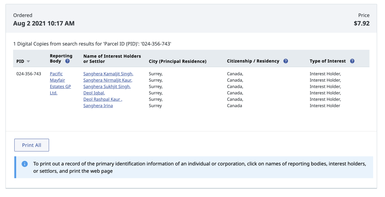
According to the Land Owner Transparency Registry, a company incorporated in February 2021 called Pacific Mayfair Estates GP Ltd, is controlled by the Sanghera/Deol family. The same principals of the San Group.
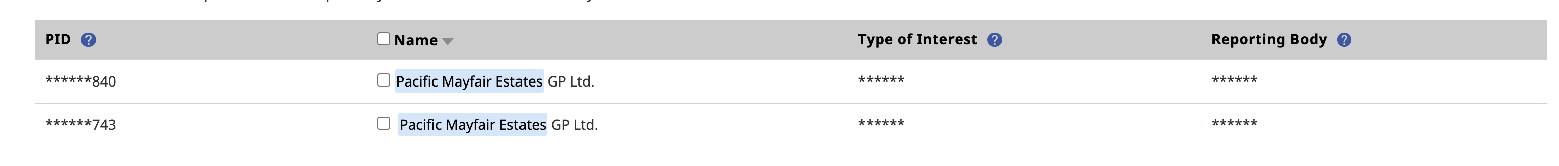
Pacific Mayfair Estates only has interest in two properties in British Columbia.
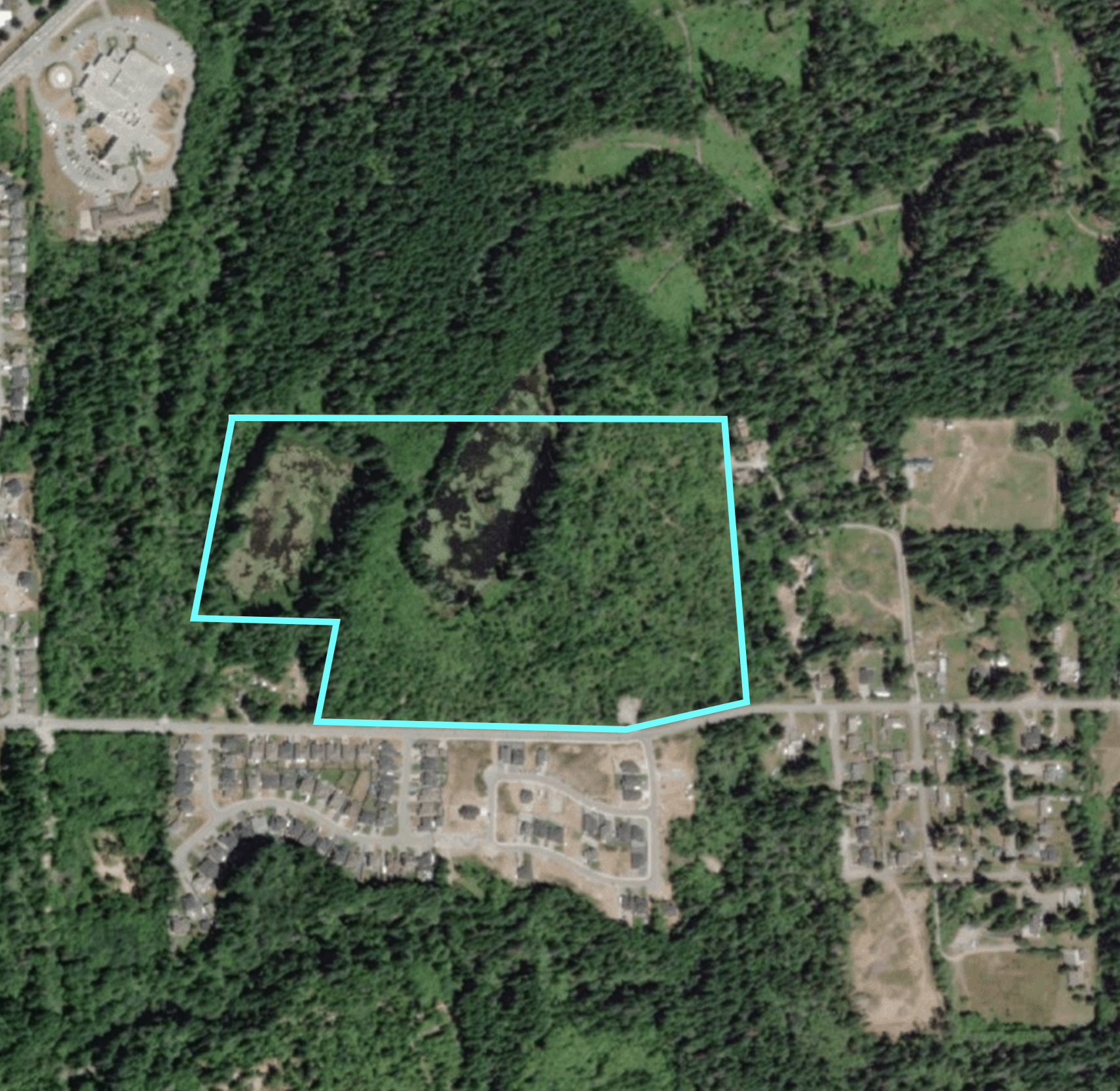
The circumstances of the Beaver Ponds (aka: Burde Ponds or even Redford Ponds) lands is complicated.You could generally say that the Beaver Ponds comprise three properties which you can see below:
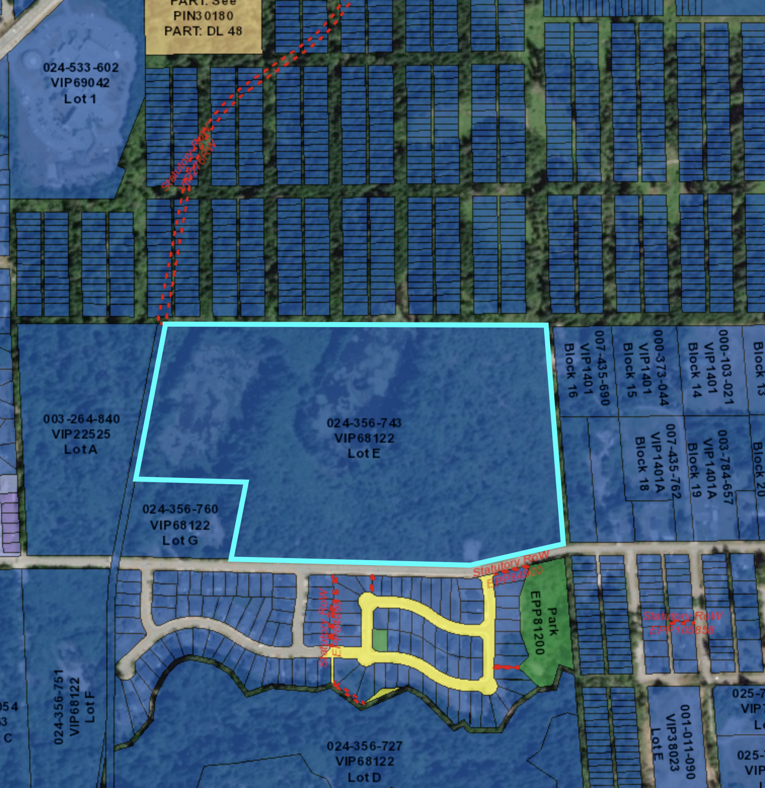
Lot A (003-264-840) is the area to the west, downhill, side of the Log Train Trail/Burde St Trail, and appears to be owned by Pacific Mayfair Estates. I did not pay the additional $8 to confirm this… but I think it is a very safe assumption based on the numbers revealed in the search above. According to BC Assessment it was sold in January 2021 (presumably to Pacific Mayfair) for $540,000.
Lot E (024-356-743) is the area to the east side of the Log Train Trail which actually hosts the majority of the pond and wetland area and people will most associate as “the Beaver Ponds”. According the records I received from the LOTR, (see the first image) and BC Assessment this lot was sold to Pacific Mayfair in March 2021 for $5,000,000. These lands have been privately owned for many years. They also have been coveted by the community for a long time. They are the headwaters of Wolff Creek which drains into Roger Creek.
Lot G (024-356-760) is privately owned (the “Harris Property”) and has been for many years as far as I am aware.
Land between Beaver Ponds and Hospital
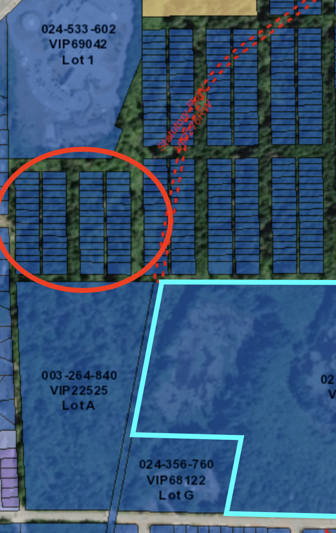
The area circled in red lying between Lot A (owned by Pacific Mayfair) and the Hospital is unclear.
I would have thought it was either Crown land, or owned by the City, but according to the Land Ownership maps on Google (provided by the BC Government), it is privately owned as indicated below by being shaded yellow.
So it is possible that this land has also been sold to a developer. Again, Pacific Mayfair is only listed as having interest in two properties, Lot E and Lot A… but as this has happened very quickly over the past few months, they could also be taking ownership of and reconfiguring the circled parcel beside the hospital as well.
It is also important to note that the area directly to the north of the Beaver Ponds through which the Log Train Trail goes is a Crown woodlot controlled by Hupacasath First Nation.
Zoning History doesn’t necessarily match use or OCP.
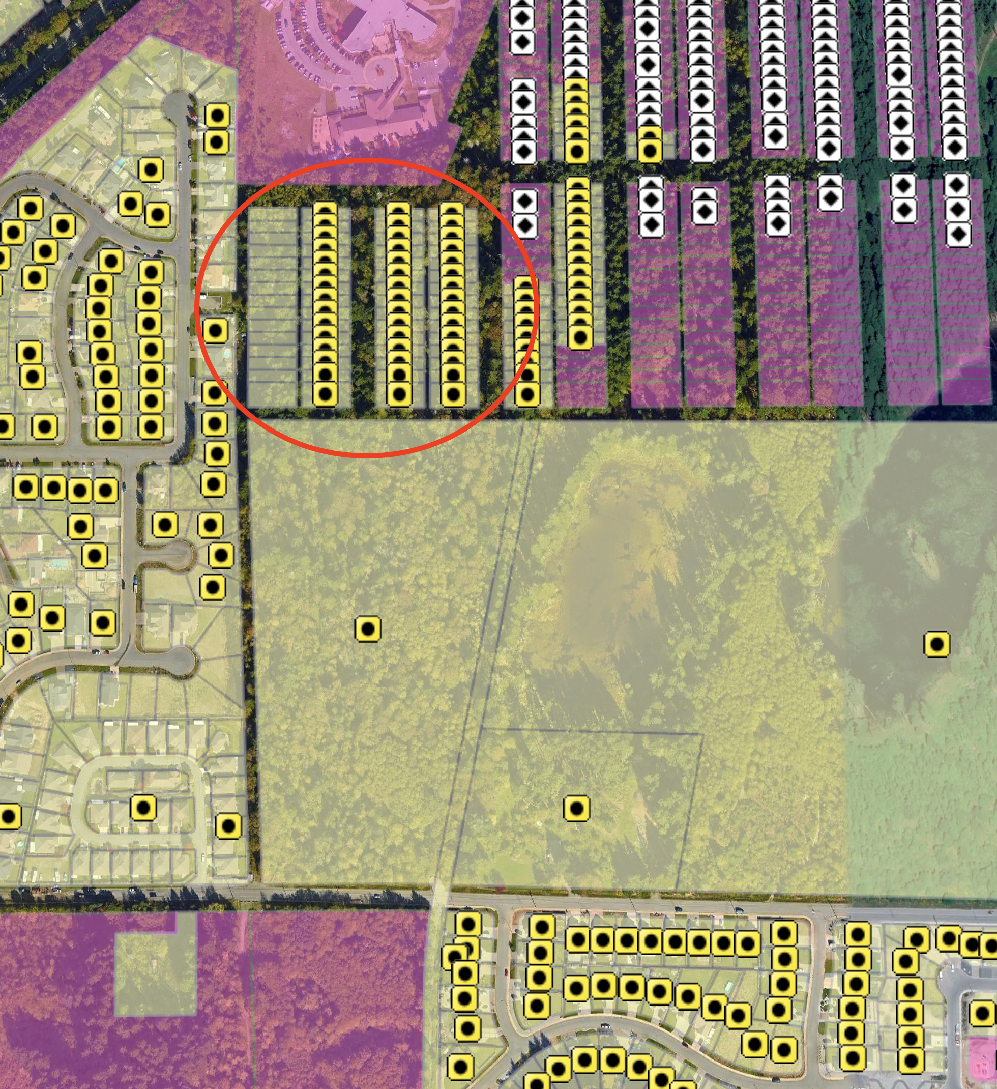
The problem the community is going to have with these lands is that unlike a lot of other undeveloped land, the Beaver Ponds are privately owned and have quite a mix of zoning. So while the OCP lists them as undeveloped, the zoning has indicated other uses for at least a decade. Only the ponds and marsh themselves are actually zoned as park as you can see below.
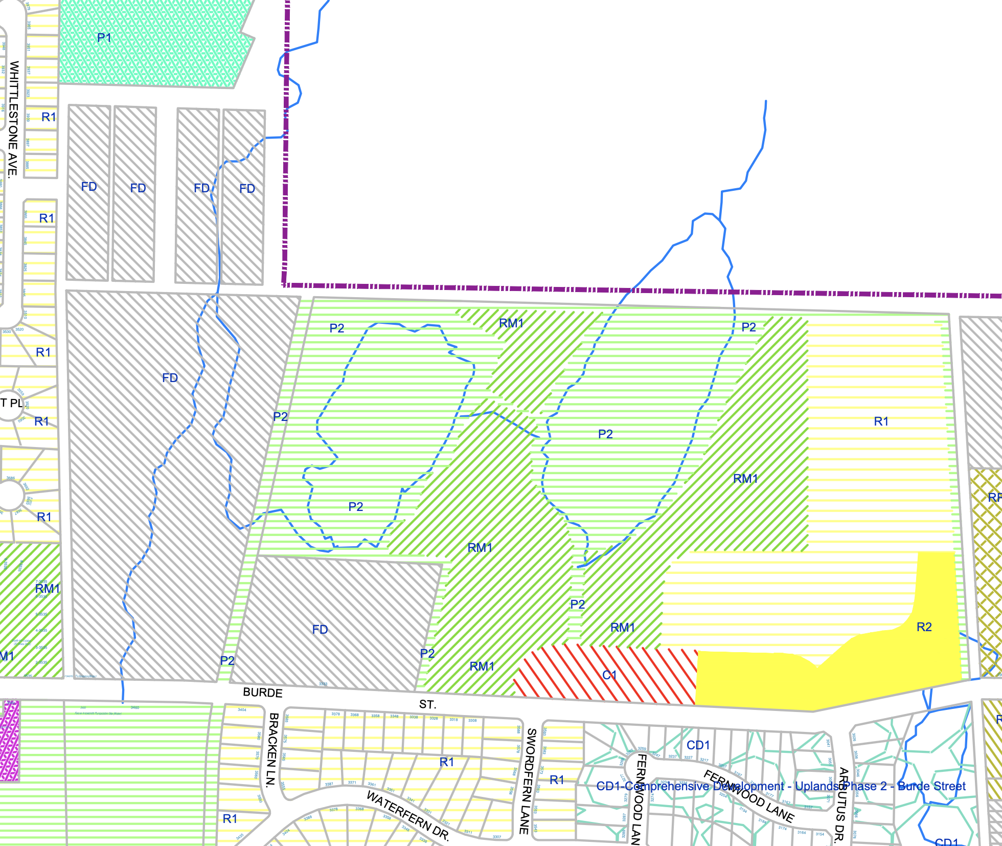
The map above is the zoning map as of June 2021. Notice that Lot G, the Harris property at 3333 Burde, has never actually been zoned as residential even though it has a residential property on it. There was an attempt to rezone it from “future development” to rural residential (Bylaw 4890 in 2017) while I was on Council but the rezoning was never approved. It remains “Future Development”.
The map above shows that there is an area of Commercial as well as Residential zoning land on the eastern side of the ponds and multifamily zoning all around the ponds. However, none of this zoning has ever actually been put into practice.
The reality is that the lands remain largely undeveloped with only a trailer on the Harris property, and a dirt road on the east side of the Ponds property.
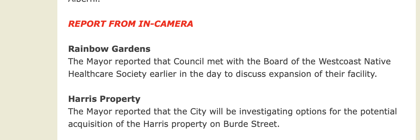
City looked to acquire “Harris Property” in 2015.
The City has been aware of the community’s want to protect this area for a long time. To that end, the May 11, 2015 Report from City Council reported that the Mayor (Ruttan) was investigating the potential purchase of 3333 Burde from Mr. Harris.
Obviously this never came to fruition. To actually protect the Beaver Ponds and all of these lands from development the City would need to acquire them in whole or part. It probably could have been done for less than $1 Million for 3 properties in 2015.
Unfortunately, it looks like the price would now be north of $6M for the 3 properties together.
The Cost of living up to the Community Vision
The area is specifically mentioned in the Official Community Plan (Page 24).
“Redford Ponds and tributaries and similar environmentally sensitive areas comprise significant wildlife habitat and shall be subject to habitat protection policies as determined through detailed environmental analysis.“
While it is possible that these lands could be subdivided and portions of them kept natural, we all know how the ‘divide and conquer’ model of habitat destruction works.
The best way to protect the Beaver Ponds is to ensure as much as possible is not disturbed.
Since we are actually only dealing with 3 properties, it remains relatively simple, if costly, for the City to purchase these lands and protect them as a park, or for the owners to donate or bequeath them to the City.
As real estate prices rise not only does it become more costly for the City to acquire and protect these lands, but it also becomes more lucrative for real estate developers, like Mayfair/San Group to push to have them developed.
Official Community Plan – Future Residential Must Have Neighbourhood Plan
Remember that the Zoning Map and the Land Use Maps are two different things. The Land Use Map is in the Official Community Plan and according to it, these lands are still “Future Development” or “Parks and Open Space”. Any change to that use should go through a Public Hearing. And there is more….
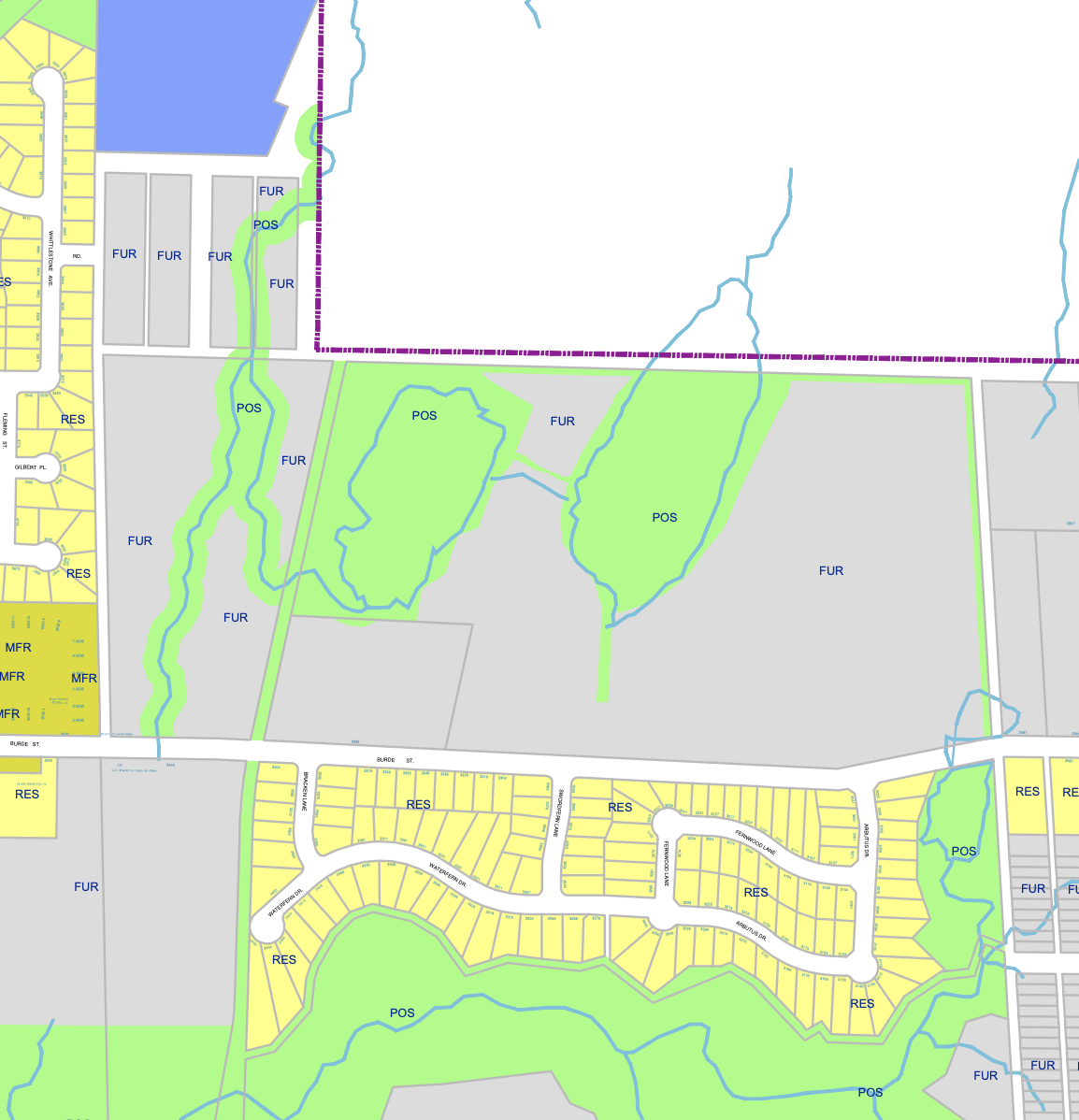
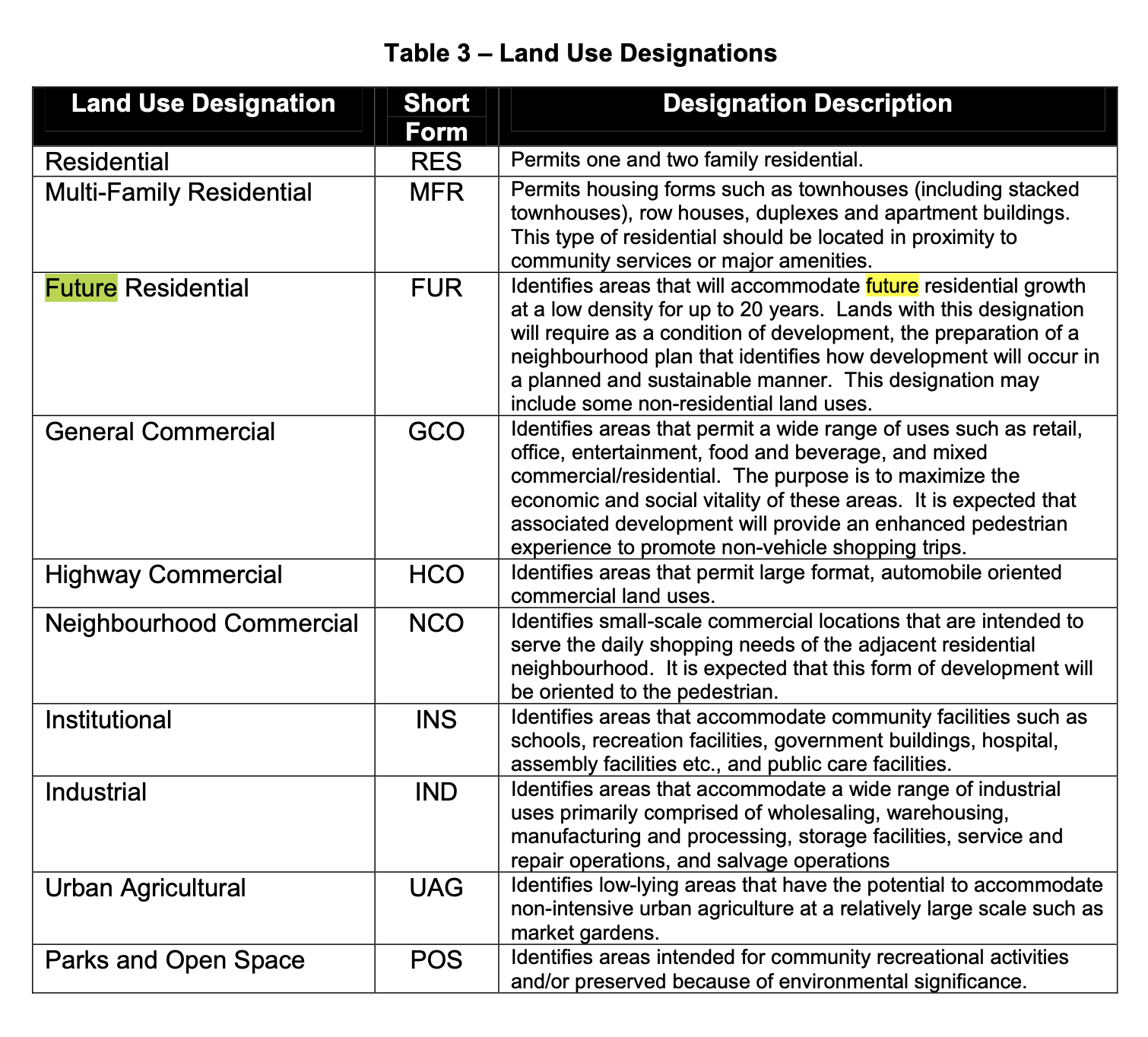
Future Residential “require as a condition of development the preparation of a neighbourhood plan that identifies how development will occur in a planned and sustainable manner“.
That means Mayfair (or Harris) would need to produce this plan to the City. It is not a veto, but it is a requirement.
City Park Dedication Rights – Fish Habitat concerns
Two more points folks have brought up or that I forgot to mention:
#1: The City when it is subdividing land for development, can require dedication for park space as part of the development. If this was made a bylaw then a referendum would be required for any further changes to the park space.
#2: Wolff Creek is a fish bearing stream and the marsh and ponds may also have fish in them. This means they will have at least some protection under BC’s environmental laws including large set backs to preserve trees around the waterways on both the Beaver ponds and the Lot A.
What can you do…
If you are concerned about the development of these lands, this might be the first place to start.
- Ask the City if they have received a neighbourhood plan.
- Ask the City when the community would be consulted.
- Ask the City whether a detailed environmental analysis has been done, as mentioned in the OCP, to determine potential impacts of development on the ponds
- Ask the City whether this all falls in line with protecting the Redford/Burde St ponds?
- Ask the City why it has not acquired the lands for parkspace.
- And perhaps – Ask the San Group if it is going to listen to the community, or develop an environmentally sensitive area — or donate it to the community.
- If San Group pursues development, make sure the City requires there to be park space as a condition of development and make sure the BC Ministry of Environment is engaged in protection of the ponds and fish habitat.
I hope this post helps to illuminate some of the issues around these potential developments. If you have any questions, comments, corrections, or concerns, please do let me know in the comments or give me a call or email.