
Final Update:
I’ve updated my post about Taxes in Port Alberni readers here might be interested in it. If you want a more in depth look at why taxes are set the way they are, this classic post from 2016 might be worth a read. I am currently working on two new posts. One on the wider Environmental Impact of the Maquinna trail development.
New post is up: Montrose and 15th – City Obligations for Environmental Impact – Storm Water – Fish Stream Protection!
New post os also up about 11th Avenue Park: In Good Faith – Selling 11th Ave Park requires Referendum or AAP
and one on how best to raise property tax revenue while minimizing tax increases for residents and businesses. Hint: The sprawl of single-detached home subdivisions on the edge of a city *increases* municipal taxes for all residents.
Updated again (Friday afternoon)
I visited both sites today and took pictures of the creek, trail, and forested area near Maquinna trail. Check them out in the Maquinna section…though this might require a second post dealing with the creek.
Updated! (Friday morning)
I have added critical legal information to both the 11Ave park section and Maquinna section. The OCP requires a neighbourhood plan for the latter, and the Community Charter and OCP may change the plans for the park and proceeds of any sale.
Original start of post

The City of Port Alberni announced on their Facebook page yesterday (publicly available link) that they posted two requests for proposal to dispose of land. You can see the RFPs on the City’s Bid Opportunities webpage.
Here’s the full text of their announcement.
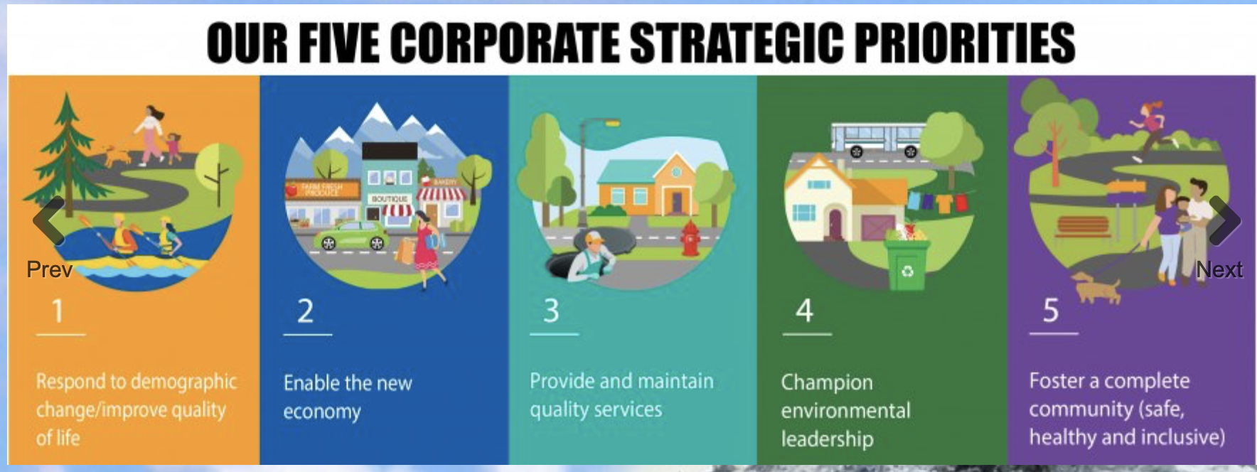
In alignment with Council’s Strategic Plan to make the highest and best use of City-owned assets and in an effort to respond to demographic change and improve the quality of life for all citizens, we are happy to announce the City has identified two vacant City-owned lands and is making them available for sale for potential residential development.
Council recognizes the challenges associated with the current tight housing market and the limited availability of serviced building lots within the City. Request for Proposals have been issued for these City-owned lands so they may contribute to the vibrancy, growth and quality of livability in the community.
These lands are currently zoned as ‘Future Residential Development’ and ‘Parks and Recreation’, and will be suitable for residential dwellings consistent with the surrounding properties.
The proposed sale of land near 15th Avenue and Montrose will not impact the nearby forested walking trail. A portion of revenues from the sale will be used to make improvements to the trail and parking area. Correspondingly, a portion of revenues from the sale of the 10th Avenue parcel will be used to plant trees in the adjacent park.
Prior to any final sale, the lands will likely be required to undergo a public Official Community Plan and Rezoning process.
For full details the Request for Proposals can be found here http://ow.ly/b8Mi50FwcGR
View Council’s 2018-2023 Corporate Strategic Plan here http://ow.ly/JkR450FwcGS
If you have already read my post in March “Port Alberni’s Future Development Zoned Land – Green Space or Urban Sprawl?” then this might not come as much of a surprise as I speculated based on comments by Councillor Poon that the City was looking at land to sell and develop, much of it forested.
What was more of a surprise in this announcement though was the disposal of a portion of 11th Avenue park.
Where is the Process – Official Community Planning and Public Consultation
At the outset the greatest concern raised by these announcements is the lack of public consultation or process. There does not appear to have been any discussion about the Request for Proposal in a public council meeting prior to them being posted.
Furthermore, with the Official Community Plan (OCP) being woefully out of date — it came into force in 2007, consultation started in 2004 — it is worth asking whether these changes, which would require amending the OCP, are what the community envisions as part of the future of the City.
That said, the OCP does provide critical guidance. More on that in the detailed sections below.
If a proposal to purchase the land was accepted, the City would only be required to notify the public through its normal signage and advertisements for comment. The subdivision and rezoning applications would go through the Planning Commission, which is generally a simple and quick process with no public consultation, and hold just one public hearing for the properties.
They could even deal with both properties in the same public hearing.
While the properties may seem small, they do represent significant changes to the use of the land in question and they represent a loss of city owned assets after their sale. So significant public consultation is not only best practice, it should be common sense.
Inline Addendum — Consultation with First Nations
A reader reminded me that I failed to include mention of the City’s moral, if not direct responsibility to consult First Nations on any disposition of land within its borders. Especially, one would think, undeveloped land that has likely been in the City’s possession since its creation out of the un-ceded territories of the Hupacasath, Tseshaht, and Nuu-cha-Nulth people.
This would have very likely been included or at least come up in general consultations in the public but that never happened.
There is also a specific government-to-government obligation under UNDRIP that the City should engage with First Nations and obtain their Free Prior and Informed Consent before considering any changes in their lands.
It’s a statement on the learning I continue to need to do to train myself to ensure this is at the forefront of these kinds of issues in our community. If reconciliation and decolonization is truly going to happen, it should be automatic that we work with First Nations governments to ensure changes and updates within the community reflect the values of the First Peoples on these lands as well.
Hupacasath First Nation manages forest land to the east of the Maquinna property, so there is certainly a possibility that they in particular will have a deep interest in the potential change of land use.
11th Ave Park – can the City dispose of parkland so easily?
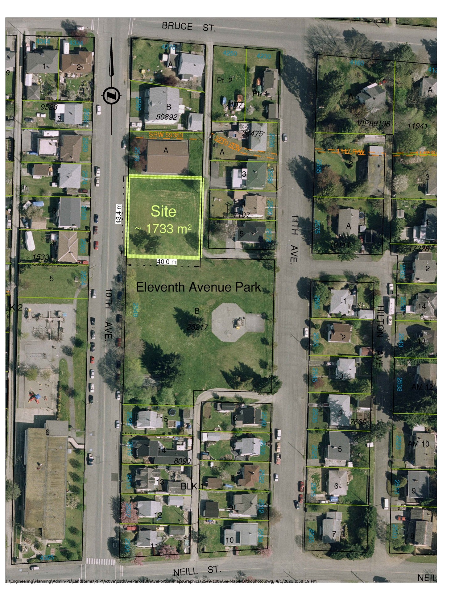
The plan appears to be to subdivide the existing park and sell a portion that is facing 10th Avenue.
A BC Government website states:
Because of the significance of parks to community values, elector approval is required for disposal of parklands or the removal of a park dedication.
The important part in that sentence is “electoral approval”, which means a referendum, or alternate approval process must be held before Council can move ahead to sell parkland.
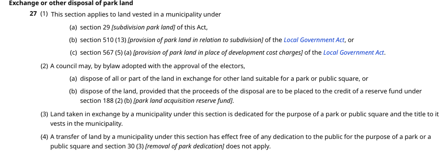
Update: Even after a successful referendum, the Community Charter also requires that the cash from sale of park lands must go into a Park Land Aquisition Reserve Fund to be used for acquiring new park land. Whether those funds can be used to plant trees in the remaining park is an open question.
However, the City is treating this land as “fee-simple” with no dedications or other encumbrances on it. And so it does not believe that an electoral process is required.
I have submitted a question to the Local Government office to confirm whether or not this park has a dedication or falls under any other designation that would trigger an electoral approval process under Section 27 of the Community Charter.
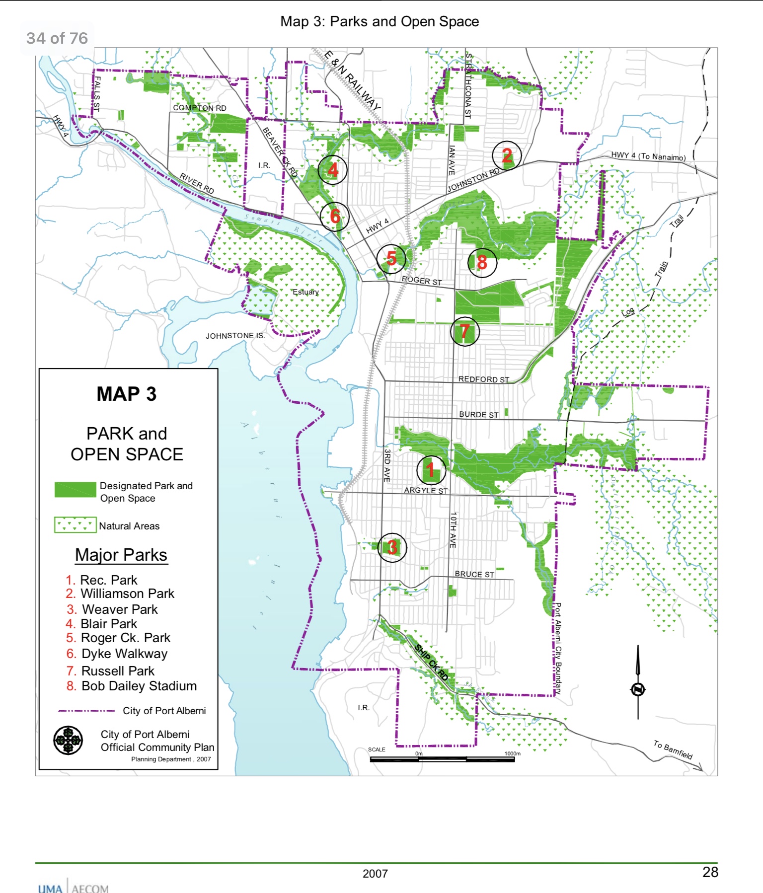
Just two community parks in the area.

The areas circled above represent the land zoned as parks south of Argyle and north of Ship Creek Road. This is a distinct and large neighbourhood in the City. I would estimate it hosts at least 1/4 of the population and homes (approx 4,500 people).
The red circles are lands zoned as parks that are natural spaces or playing fields. They do not feature any playgrounds or other community infrastructure. The purple circle is the entrance to the Maquinna trails. More on that later.
That leaves just two city parks in the area: Weaver Park and the impacted 11th Avenue Park.
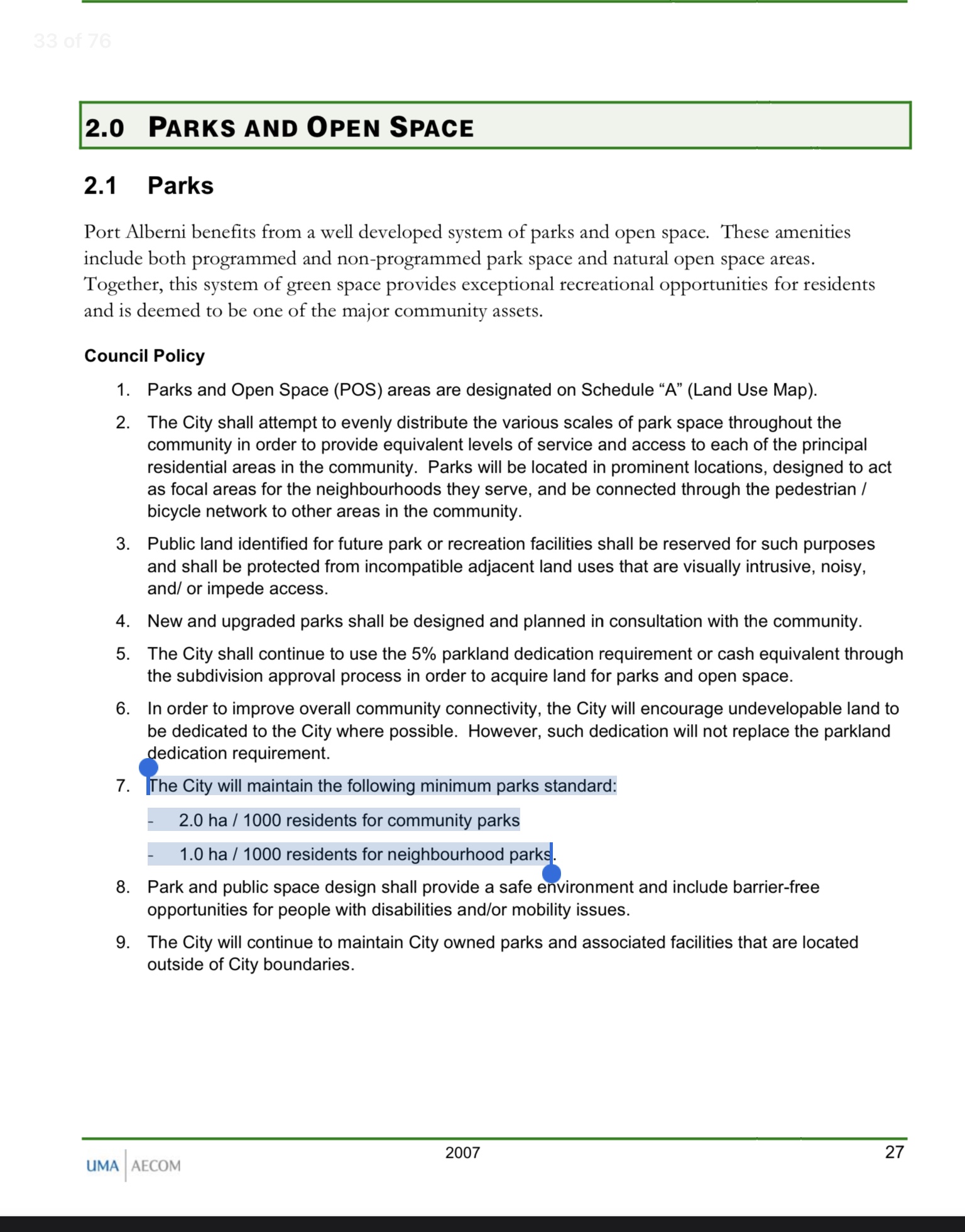
UPDATE: The Official Community Plan designates that the City must have 2 hectares (5 acres) of community parks (like Weaver or Rec on the map below) per 1000 residents and 1 hectare (2.5 acres) of neighbourhood parks (like 11th Ave) per 1000 residents.
A question to ask the City would be whether they have done the calculation to ensure that losing the portion of 11th Ave does not mean going under the 2 hectare requirement. Best practice would be for the City to add neighbourhood park space to balance what is being proposed to be removed.
While there is infrastructure available at Maquinna Elementary and the Kaleidoscope Park/Hilton, these facilities could be closed to the public or the properties redeveloped, or sold independent of any consultation with the community, as happened at John Paul School which was the only playground remaining in the Central Port Alberni area below 10th Avenue before it was fenced and gated a few years ago.
The slow decline of parks and community spaces in Port Alberni
Port Alberni residents have been losing access to community space for decades. Many former playing fields, or community parks, like near the Dyke, to small parks in the Cedarwood area, to the former West Coast General Hospital area, and little known parks like Seaton and Somass. Many have been allowed to decline and with the downsizing and consolidation of neighbourhood schools, many have been lost forever.
The exception has been the addition of Canal Beach and the new Millstone park near Victoria Quay. But as a whole, unfortunately, our access to green space for all and especially playgrounds for kids within the City, in its residential neighbourhoods, has greatly diminished.
If you do not have a car, it is often a long walk, or bus ride to get to the nearest park.
I’m not clear what need the City would be fulfilling by selling a portion of an already small amount of park space. The subdivided property, which would be behind the bench you see below, would be a loss of open community park space, again, something very rare in the City.

There are no requirements in the Request for Proposals under the City’s Objectives for type or character of the proposed development.
While a multi-family housing development on the property could be beneficial to the area, especially if it included affordable housing, there are other ways that the City can encourage redevelopment and “in-fill” of existing single-family and other low density housing to meet this need.
Removing already scarce community park space from neighbourhoods is not a good way to create a liveable and desirable City.
15th and Montrose – Maquinna Trail development – UPDATE – Neighbourhood Plan Requirement
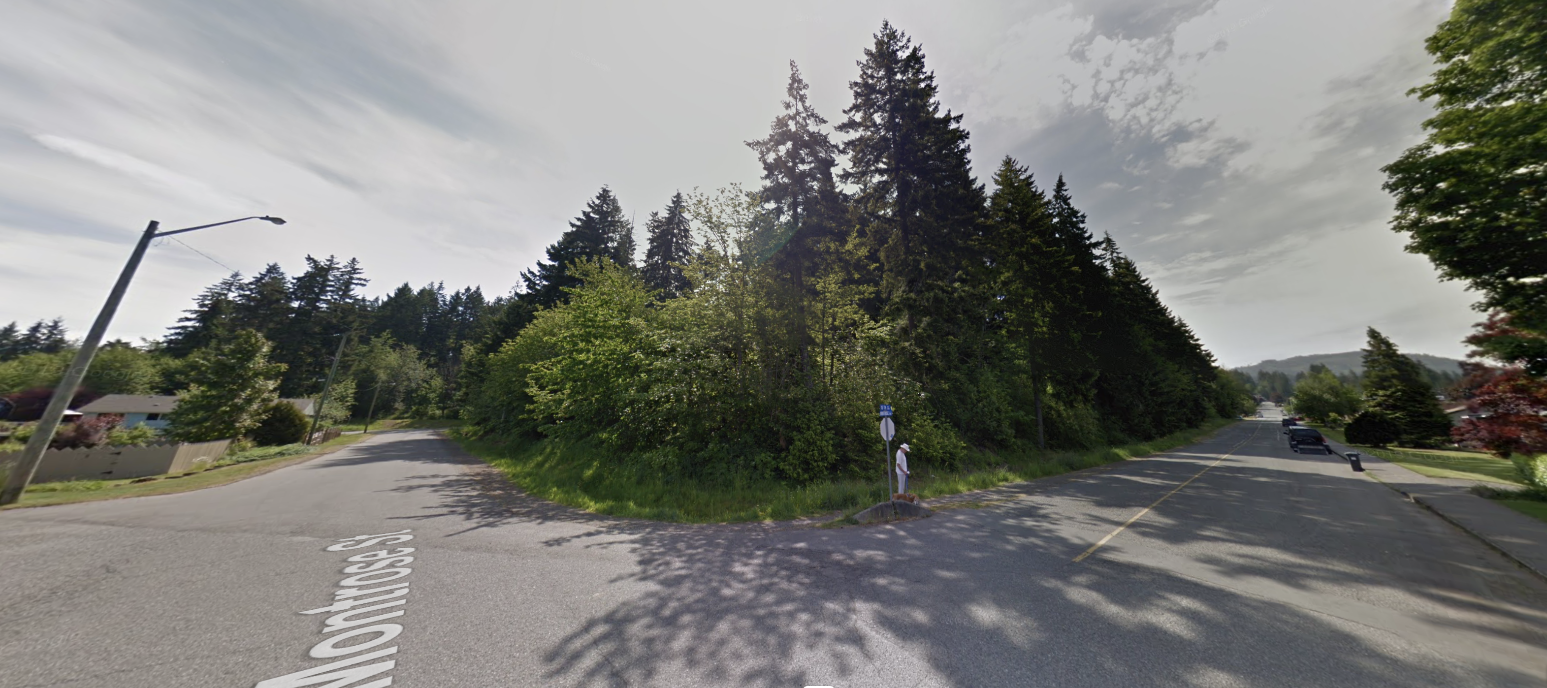
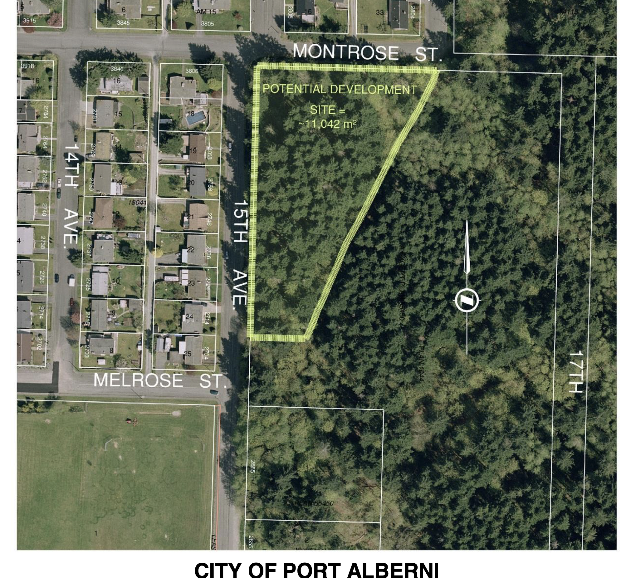
That brings us to the 2nd property at 15th and Montrose, behind Maquinna School. Here is the corner of 15th and Montrose.
This appears to be a straight up sale and development of greenspace on the edge of the City. The property is zoned as Future Development so it does not have any of the potential encumbrances of 11th Avenue park.
UPDATE However, I was just reading through the OCP and came across this:
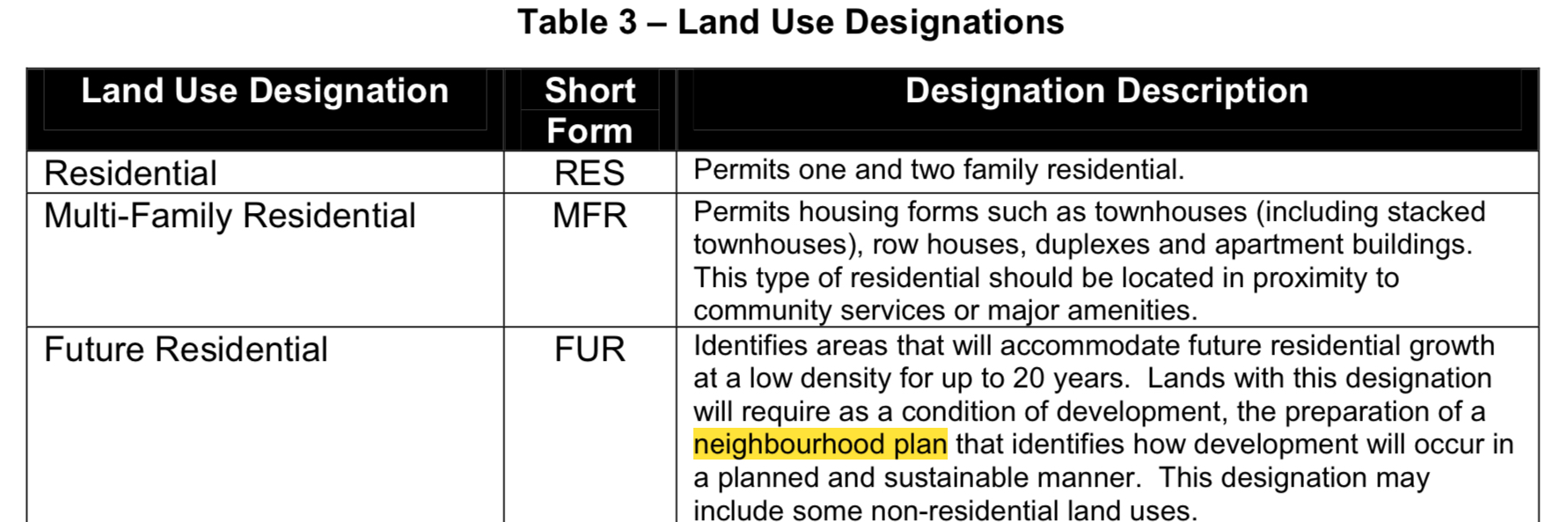
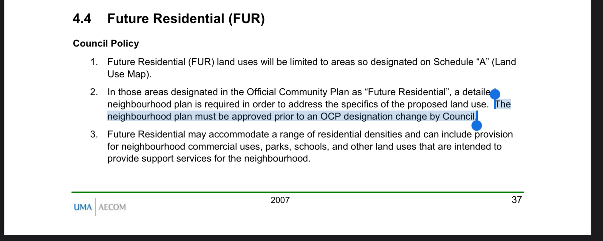
“Lands with this designation will require as a condition of development, the preparation of a neighbourhood plan that identifies how development will occur in a planned and sustainable manner.â€
A neighbourhood plan created by the City would involve public consultation with the neighbourhood as well. This has obviously not happened so I question whether the City is adhering to its own Official Community Plan.
By ignoring this requirement, the City is opening itself to legal action by residents for not following its own legally adopted bylaw.
As you can see from both the Google street view and the City provided map (also Google based), this is an approximately 2.5 acre piece of land (11,000m2) with a combination of deciduous trees and mature 2nd growth fir.
There are popular trails and wildlife tracts throughout this small area that connect to the Maquinna/Log Train Trail (thick brown dashed line in picture below).
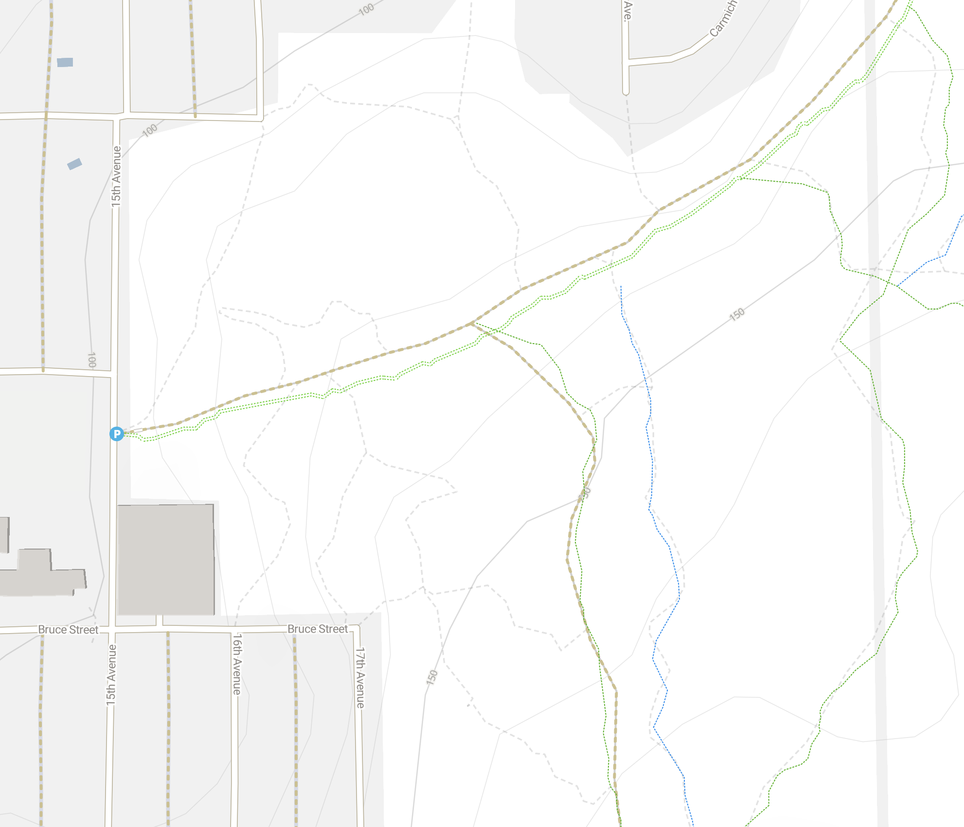
You will notice that there is a trail starting at the head of Maquinna Trail, the blue “P”, and runs diagonally to the end of Montrose which closely resembles the diagonal boundary of the proposed subdivision.
Update: I visited the trail behind the proposed development this morning. I believe the boundary is the trail and creek. This may have significant environmental concerns. Here are some pictures of the trail, and the forested area between the trail/creek and the road. There are specific provincial and OCP regulations and guidelines dealing with a potential riparian or wetland. The city may need to do an environmental assessment before approving a development that might disturb the creek and surrounding habitat.


Assuming no roads were build as part of the development the space would be suitable for about 10-15 standard width single-family residential lots with extended backyards or some green space butting up against the trails and forest.
It could obviously also host a large residential building of some sort as well but it seems the most likely result here would be a new line of single homes selling at market rates.
However, again, all of this is just speculation. Under the OCP the City is “required†to create a neighbourhood plan when development these Future Residential zoned designated areas.
Write the City with your concerns.
While it will be easy to vent on a social media post (or a blog 🙂 ) the most effective way to bring your opinion to the City is by writing a letter or email or attending a council meeting.
Unfortunately, since the City appears to have chosen not to follow any kind of consultation process for the disposal of these park and natural lands, it will be up to the public to raise the issue with the City directly either as individuals or groups.
I personally fail to understand how these sales would achieve any of the goals stated in the City’s Strategic Priorities. In fact, I see them as very much the opposite.
If you have any questions or comments about this or anything I’ve written, please do leave a comment, shoot me an email, or give me a call.
Take care.
Chris
Thanks for writing about this. I live across from there and use that trail almost every day. I’m pissed about what the city is doing and how they are doing it. I posted your article on AV Chatter but the response has been lukewarm at best. However, I know several residents in this area that are also torqued about what is happening. They (the city) have already done so much work to make this happen, and we, as property owners and tax payers, have had no input. And no idea it was happening!
Hi Kim,
I don’t do Facebook anymore so thanks for sharing it on there. It is important that people know they are not helpless even when the City moves very quickly like it has here.
There are a whole host of ways the City has overstepped its authority here. The OCP is the guiding document of the City, or is supposed to be, so I highly recommend you and anyone else who is concerned to download it and read it.
The most important points for that area will be the requirement for a neighbourhood plan before any amendment can take place, which the City seems to have ignored. I am also writing a post about the environmental piece in particular. The creek that runs along the boundary is a tributary to Owatchet / Dry Creek. The OCP says all watercourses are to be preserved “in their natural state†and there are provincial regulations that govern how local government is supposed to approach streams like that including with an environmental assessment.
If you have any questions, don’t hesitate to reach out.
Cheers
Chris
I’ve finished the 2nd post about the environmental aspects. This will be more that you can bring to the City to at least slow them down.
https://chrisalemany.ca/2021/07/17/montrose-and-15th-city-obligations-for-environmental-impact-storm-water-fish-stream-protection/
Good luck! This is the globalist agenda you helped bring in… 🙂